

The famous Greek philosopher Plato stated that “necessity is the mother of invention” and an outstanding example of need encouraging extraordinary creative efforts can be seen in the wide range of technologies developed by nations engaged in protecting the lives and wellbeing of their citizens.
World War II saw outstanding and rapid advancements in new materials, rocketry, electronics and communications. For example, Nylon is a durable synthetic material that was developed by DuPont as an alternative to natural fabrics that became scarce due to World War. Today, it’s still one of the most heavily used polymers for clothing and other goods.

Scientists in Afghanistan supporting the New Zealand Defence Force operations with their DTA-developed UAV technology.
Military research is now seen not only as a basis of improved defence capabilities but also as a basis for civilian technologies. For example, the internet started as a 1960s defence force project in the US that had the objective of connecting several super-computer sites in the country with one another so that if any one of them was destroyed by a nuclear explosion, then the remaining computers would continue to function. Another example is Global Positioning System (GPS), which is now so common that every smartphone uses it for location services. This network of satellites was originally set up by the US Department of Defense in the 1970s for military purposes, such as giving submarines accurate positions for missiles launched. President Ronald Reagan ordered GPS to be made available to civilians once it was completed, while President Bill Clinton later declared that the highest quality GPS signal should be available as well.

The UAV autopilot.
Although not of the scale of larger nations, New Zealand maintains an R&D capability in its Defence Technology Agency (DTA) to adapt and apply technology for New Zealand’s defence purposes.
The results of this R&D work tend to be pragmatic and particularly relevant to New Zealand. Some technologies have already been transferred to local businesses and there are others under consideration. Here are some of them.
SurfZone View – a safety tool for beach landings
Moving people and equipment from the sea to the land is one of the most complex tasks completed by the New Zealand Defence Force (NZDF). Amphibious operations are required when port facilities are not available, most commonly when we are supporting our neighbours in the Pacific. The safety and success of amphibious landings are largely dependent on surf conditions. SurfZone View is a modelling and tactical decision aid to support beach landing operations conducted by the NZDF. It provides a fast, reliable and simple tool that can be used by command teams to plan and execute safe and efficient operations. The software provides a robust prediction of nearshore waves and currents, and has been transferred to a New Zealand organisation interested in understanding coastal conditions.

SurfZone View ensures beach landings are safer.
Unmanned Aerial Vehicle (UAV) Autopilot
The UAV Autopilot is a full inertial Navigation System and Attitude Heading Reference System with control, guidance and communication layers for tactical class fixed wing UAVs. The autopilot comes with Ground Control Station software that allows a wide spectrum of autonomous or semi-autonomous missions to be conducted. Some of the many features include health monitoring for flight safety and procedures to cope with situations of GPS denial. The DTA autopilot has been licenced for sale and is in use in aircraft systems in Australia and New Zealand, primarily for aerial survey.

Setting a UAV free.
Chaos-based communications system
DTA developed a chaos-based communication system that seeks to enhance the security of transmission over conventional communication systems while also maintaining or enhancing their anti-jamming and Low Probability of Intercept / Low Probability of Detection properties. These features make it of interest to both the military and commercial sectors, such as the banking sector, where voice and data security over wireless channels are of paramount importance.

DTA researchers flying a UAV from a depolyable ground station.
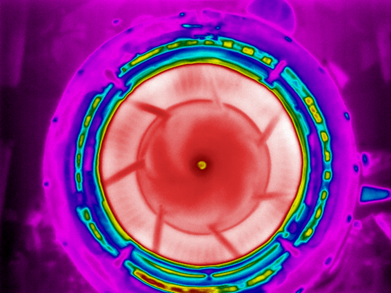
Infrared imaging
DTA has also developed a system for detecting potential damage in gas turbine engines. Through analysis of footage from an infrared camera coupled with a special telescope, the system automatically detects and tracks temperature changes that may indicate a fault in the turbine or combustion section of an engine. The early detection of such faults will avoid expensive and potentially dangerous accelerated turbine damage.