
 ?Software developer Clint van Marrewijk realised that huge amounts of data were available – just not a way to use it to help the average New Zealander. The result, Thundermaps, can tell you useful things (such as if your house is on fire). Run, don’t walk.
Clint van Marrewijk learned a thing or two about the power of data and smart targeting when he helped develop back-end systems at Gareth Morgan Kiwisaver. So when Kiwibank picked up that business in 2012, van Marrewijk saw the chance to create a venture that would serve up data in a way that’s meaningful to, if you’ll excuse the hackneyed election-year phrase, the average New Zealander.
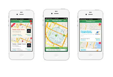
The result is Thundermaps, which includes a function – among others – that lets users know if their house is on fire. No, we’re not kidding.
Most information Thundermaps taps is public, so it’s open to be trawled, but the mission to make that data valuable means alerting users only if something happens in their defined area of interest.
Users set that area by drawing a circle on a map and letting Thundermaps detect that location, then opting for the data they want alerts for. Once they set login details, the rest is down to geocoding, where co-ordinates are found from data (such as addresses) and can be used in conjunction with geographic information systems.
Thundermaps’ system scrapes each data set and feeds through what the user has ordered.
For example, you could search Trade Me every day for rental properties, but it’d be easier to get an alert just for that Grey Lynn bungalow or Oriental Bay villa. Unless you’re an emergency junkie, you won’t want a broadcast of every road crash or fire, but you’d want to know if it was your house ablaze or there was a serious prang in your street.
It seems there are more than a few emergency junkies in New Zealand – the extension of a free fire alerting service Thundermaps offered in Australia drummed up serious interest here.
And if you want to suss your risk of being struck by a drone on a visit to the US, the Bureau of Investigate Journalism’s Drone Strike activity is on Thundermaps’ menu.
The desktop and app service will stay free, van Marrewijk says, but it makes money from private accounts held by teams like site workers, who get alerted to things like hazards, incidents and infrastructure faults. But the possibilities for growth are limited only by what locals want to know.
That extends to weird and wonderful things as well as information to plan your life by. Rainfall levels in Canterbury? Check. Shopping and entertainment coupons? It’s there. Earthquakes anywhere with magnitude of more than 4.5? No problem.
There’s even an alert for what’s trending on Twitter in your neck of the woods and Instagram photos tagged #nature.
A mechanical engineer by trade, van Marrewijk has moved through quantitative analysis, software development and project management. Combine those skills with a prototype he recruited a developer to create, later developed by Wellington’s Rabid Technologies in partnership with his company Cloudsource’s developers, and there was a formula for a sellable product across a broad audience.
“[Gareth Morgan Kiwisaver] dealt with big data sets to target certain people. I could see how valuable that was from the business side of things. I realised there were all these massive data sets but no way for normal people to access that data.”
The venture’s come a long way in two years, exhibiting at the BNZ Startup Alley at last year’s Webstock conference. It now has more than 1600 users and a library of public data spanning organisations in several countries.