But that’s the brave new world we find ourselves in as New Zealand councils roll out smartphone apps covering everything from available parking spots to building consents, accommodation directories to defibrillator locators.
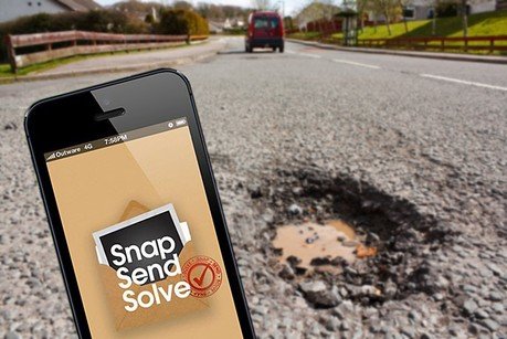
Perhaps fearing the appearance of Wanksy-type vigilante, Christchurch City Council’s latest release takes aim at city-wide maintenance tasks with a mobile application that lets citizens snap pictures of potholes and other annoyances and send them to the council for frictionless resolution.
The app, Snap Send Solve (available via the Apple app store and Google Play), was soft-launched last Friday, with Council Information Technology Service Manager Dana Burnett saying the app will speed up the resolution process by using pictures and GPS location data, and directing the request to the relevant department instantly.
“The goal we are trying to achieve is to increase the number of ways people can send us their issues,” says Burnett.
“We’re not trying to reduce the numbers of issues people are reporting, we’re trying to increase what we can do. Using Snap Send Solve, we can get the precise location [of the issue] at the moment it’s reported, and that saves times and money.”
Burnett says the app is already successfully in use in several Australian locations and makes financial sense for a council looking to streamline the resolution process.
“We’re the first council in NZ to be using Send Snap Solve so we do feel as if we’re breaking a bit of new ground. We’ve bought it and had it configured specifically for us, so that it can identify the kinds of issues we want it to report on, and so that is delivers the right geographic location.”
“It costs $11,000 per annum to use it—which is fantastic because we couldn’t possibly build it for that—and included in that price is ongoing maintenance and a strategy for ongoing upgrades.”
Other councils are following suit too. Wellington’s MetLink Realtime iPhone app, released on Monday, allows travellers to access up-to-the-minute information on bus and train arrival times based on GPS data.

Auckland Council’s head of information services, Mike Foley says that councils are in a period of rationalisation at the moment, looking to manage communication channels more efficiently while meeting a growing expectation that digital solutions will be available to consumers.
“People want to transact when and how they want, and that’s usually not by going into a branch,” says Foley. “So we’re looking at how we engage with citizens, whether that’s face-to-face, via kiosks, mobile apps or the internet.”
“Of course self-service is always going to be cheaper to deliver than face-to-face, so that’s what we’re working through, but fundamentally we want to make it friendlier to operate with the council. If we can do that, it makes life better for everyone.”
Foley says that while the focus is on providing customers with efficient transactions in the first instance, councils are still cognizant of the value of the data being collected and the myriad applications it could have.
“It’s a way downstream for us at the moment, and we’ve only started to collect that data now, but there is potential there for us [to work directly with business] as we build up our platforms.”
“There’s the potential for us to provide that information to third parties—with proper attention to privacy issues of course—but with us acting as the information provider. If you look across the globe, that’s the way things are going, with that data being used for a lot more than transactions.”