Just as the Earth will always shake, so too will the humans always innovate: Idealog’s guide to earthquake tech
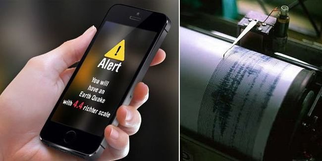
Emergency alerts
No one yet knows how to predict when an earthquake definitely will or will not happen, but there are ways to let people know how to get to safety when an earthquake does hit. Warnings can be sent to smartphones and other devices urge people to seek higher ground if there is a tsunami risk. The free app MyShake records the strength of a quake and immediately sends the data to scientists.

In Japan, the Earthquake Early Warning (EEW) system alerts people around the country when an earthquake is in progress, based on two or more seismographs detecting tremors. The system can give people anywhere from a few seconds to a minute of warning before serious shaking begins – enough time to run to safety or take shelter if necessary. It can also override the “silent” function on your phone or even switch it on if it’s off while you’re sleeping.
Spatial tech and mapping
New Zealand’s skills in advanced spatial technology and geographic intelligence has underpinned much of the response to North Canterbury quake, NZTech chief executive Graeme Muller says.
“When the earthquake hit the South Island last Monday morning, spatial experts across the tech sector and government were able to quickly assign four satellites over the area, remap and identify areas of critical needs and help coordinate and assign emergency responses across the top of the South Island,” he explains. “These Kiwi experts were even able to map key areas across Wellington down to the detail allowing traffic redirection around at risk buildings. Ironically, part way through last week the spatial tech industry got together for its annual awards and we recognised the best of our Kiwi talent in a sector that is creating a fast growth export business, with Thundermaps winning the export award for providing critical mapping services for cities right across Europe.”
ThunderMaps is a Wellington-based specialist GIS app provider focusing on providing a safer world for engaged and informed cities. ThunderMaps services tens of thousands of users in 11 countries, and has offices in New Zealand, Sweden and the United Kingdom, and contracts with governments, cities and large businesses.
“Spatial tech has played such a large role in the rapid response to the earthquake and flowing into the fact, this is now a growing export opportunity for New Zealand,” says Muller. “Geospatial technology is playing a key role again in supporting government agencies and the local authorities in the Canterbury and Wellington region respond to and manage the current earthquake crisis. Eagle Technology moved quickly alongside the New Zealand Defence Force and Land Information New Zealand to task the global satellite company Digital Globe to acquire imagery over the affected transport routes. This multi-band satellite imagery is now flowing into agencies and has already helped identify the exact location and extent of damaged infrastructure. The imagery acquired in the days immediately following the November 14 earthquake provided a complete overview of the entire affected area.”
And that’s not all, he says. “Eagle Technology, Environment Canterbury and others have helped the Ministry of Civil Defence and Emergency Management and their associated regional offices develop situational awareness maps, 3D scenes, site maps and building inspection applications to gather and distribute critical information to stakeholders,” Muller explains. “Using helicopters and specialised survey equipment, engineering services company Aurecon, has been assisting Canterbury Civil Defence with landslide identification and management. This information has revealed which bridges are passable. The next phase of work by Aurecon is to use drones to undertake aerial surveys and generate 3D models and volumetric calculations of the large land slips. These techniques have been developed and refined after the February 2011 Christchurch earthquake on the Port Hills.”
Levitating foundations
It sounds pretty sci-fi, but levitating foundations are a real thing. In Japan, engineers have invented a way to “levitate” buildings off their foundations using a cushion of air. The way it works is actually pretty simple: sensors on a building detect movement and send signals to an air compressor, which then forces air between the building and its foundation. The cushion of air can lift the structure up to three centimetres off the ground, effectively lifting it “above” the moving earth. Once the quake is over, the air flow stops, and the building returns to its foundation.
Shock absorbers and base isolation
In the 1990s, the Parliament Buildings in Wellington were refurbished and strengthened with blocks of rubber and lead that were placed between the new foundations and the concrete beams. The blocks, which act like shock absorbers, are able to prevent large portions of movement generated during an earthquake from being transferred to the buildings’ foundations. This method of earthquake-resistant design, developed in New Zealand, is called ‘base isolation’ because it helps isolate the building from its foundations.
Those weren’t the only upgrades. Once separated from their foundations, a ‘moat’ was placed around the Beehive to allow it to move up to 300 millimetres during an earthquake. Reinforced concrete was also added to the walls, which were joined to the floors with a combination of concrete and steel.
Regulation
It may sound simple, but sometimes regulations and building codes can make a big difference in earthquake safety. In the US state of Oregon, for example, hot waters heaters are required to be bolted to walls, and brick structures need to be reinforced with metal going through the bricks to prevent them from collapsing in case of a quake. Here in Aotearoa, Housing Minister Nick Smith introduced a raft of new regulations in 2015 for buildings. Parliament also passed new regulations in 2016 for earthquake-prone buildings.
Animals and earthquake prediction
It may sound like pseudoscience to say that animals can “predict” earthquakes – and that’s the official position of major governmental organisations like the US Geological Survey (USGS). While there are anecdotal stories of dogs, cats, monkeys and even pandas “acting crazy” before an earthquake, numerous studies have been done on the apparent phenomena, but results have shown no known correlation. However, the USGS doesn’t outright dismiss the possibility entirely.
In a story on Smithsonian.com, Friedemann T. Freund a senior research scientist at the SETI Institute claims there is evidence that animals can predict earthquakes because they can detect the first of an earthquake’s seismic waves (the P wave, before the shaking). Last year, he and several co-researchers published a study that described how animals in the Yanachaga National Park in Peru fled en masse in 2011, several weeks before a 7.0 magnitude earthquake.
If we can figure out how to harness that power, we’ll be safe and sound.